
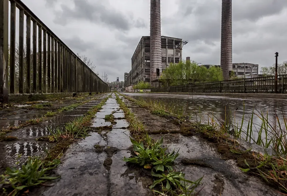
This route works best when you stop asking whether a place is beautiful and start asking what built it, what broke it and why people still stay.
This road trip begins with a building that still looks like a future somebody once believed in.
It ends in a landscape where mining damage became strangely beautiful without pretending the damage never happened.
Between those points lies a three-day drive through the Czech–German–Polish borderlands around Liberec, Zittau, Bogatynia, Görlitz, Weißwasser and Łęknica.
The region was once known as the Black Triangle because lignite mines, power stations and heavy industry produced some of Europe’s worst air pollution. Emissions fell sharply after 1989. The mines, power infrastructure, shrinking industrial towns and altered landscapes did not disappear with them.
That is what this route follows.
Not a neat collection of abandoned factories.
Not a romantic tour of communist ruins.
Not three days of pretending that poverty, decay and environmental damage become charming when photographed through a rental-car window.
The route works because it keeps changing tone.
Ještěd still looks futuristic. Oybin is almost indecently picturesque. Turów is an active open pit whose scale is more political than scenic. Görlitz looks as though somebody protected it from the rest of the itinerary. Weißwasser is rebuilding around the remains of its glass industry. Near Łęknica, former mining pits have become forests and coloured lakes.
This is Central Europe refusing to organise itself into one easy category.
The route at a glance
Day 1
Liberec → Ještěd → Hrádek nad Nisou → Oybin → Zittau
Day 2
Zittau → Bogatynia → Opolno-Zdrój → Turów mine area → Görlitz and Zgorzelec
Day 3
Görlitz → Weißwasser → Dawna Kopalnia Babina → Łęknica → Bad Muskau
Allow roughly 220 to 270 kilometres for the main route and local loops.
That sounds modest.
It is.
The driving is not the challenge. The stops, walks, industrial edges and repeated temptation to investigate one more strange building are what consume the time.
Three days is the minimum that keeps this from becoming a drive-by exercise.
Before driving it
This route crosses Czechia, Germany and Poland several times.
All three countries are inside the Schengen Area, but you should still carry:
- identity card or passport;
- driving licence;
- vehicle registration;
- insurance documents;
- rental-company permission for cross-border use where required.
The main route does not depend on difficult roads or specialist driving.
It does require a car that you are comfortable parking, reversing and occasionally turning around after discovering that an interesting-looking road leads only to a factory gate.
Do not use the route as an excuse for illegal urban exploration.
Several buildings and industrial areas will look abandoned enough to invite optimism. Fences, warning signs and closed gates remain legally meaningful even when the building behind them has broken windows.
This article deliberately uses public roads, official attractions, functioning towns and legitimate tours.
The adventure is not improved by explaining trespassing to the Polish police.
Day 1 — Liberec to Zittau
Day 1 begins above Liberec.
Not in the city centre.
Not beside the town hall.
At Ještěd.
The tower combines a television transmitter, hotel and restaurant inside one hyperboloid structure completed during the Czechoslovak socialist period. Architect Karel Hubáček produced something that still looks more convincingly futuristic than many buildings designed after the future supposedly arrived.
Ještěd is the correct opening because it establishes the route immediately.
This will be a trip through architecture, engineering and landscape rather than a sequence of town squares.
Reaching Ještěd requires current information
The historic cableway is currently out of service.
Do not arrive beneath the mountain because an old article promised an easy ride to the summit.
Drivers can use the official parking areas described by Hotel Ještěd.
The closest practical option is the Ještědka car park:
- 200 CZK (€8.28) per day;
- payment in cash;
- approximately 800 metres from the summit;
- roughly fifteen to twenty minutes on foot.
The Výpřež car park costs:
- 100 CZK (€4.14) per day;
- approximately two to three kilometres from the summit, depending on the walking route.
Do not drive the final mountain section assuming that every apparent parking space belongs to visitors.
In winter, the official advice recommends winter tyres and potentially snow chains. Mountain conditions can differ considerably from Liberec below.
Fog does not necessarily ruin Ještěd.
It can improve the building.
It does, however, remove most of the regional view and make the mountain road less entertaining.
Check the weather before committing the morning.
Liberec is the launch point, not the subject
You could spend a full day in Liberec.
Do not do that on this route.
This is not a compressed Liberec city guide with several unrelated day trips added afterwards.
Have breakfast, collect the car and use the city as an operational base.
After Ještěd, descend and drive towards Hrádek nad Nisou, close to the point where Czechia, Germany and Poland meet.
Hrádek is a useful route stop rather than a major destination. The border geography matters more than the individual sights.
This is where the road begins behaving strangely.
Country changes happen quickly. Place names switch language. A road that feels Czech becomes German and then Polish without the landscape accepting any obligation to change with it.
Continue into Germany towards Oybin.
Oybin is almost too pretty for the route
Oybin Castle and Monastery sit on a sandstone rock above the compact resort village of Kurort Oybin.
The ruins, forest and rock formations provide the first deliberate break from the industrial theme.
Take it.
A road trip made entirely from concrete, mines and declining towns would become as predictable as the scenic route it was trying to avoid.
Oybin works best as a proper walking stop.
The castle and monastery complex is open throughout the year:
- April to October: €9 for adults;
- November to March: €6 for adults.
Allow at least ninety minutes.
Two hours is better when the weather is useful.
The path rises through the rock complex, ruins and cemetery before opening to views over the Zittau Mountains. It is not a severe hike, but it is considerably more than stepping out of the car beside a viewpoint.
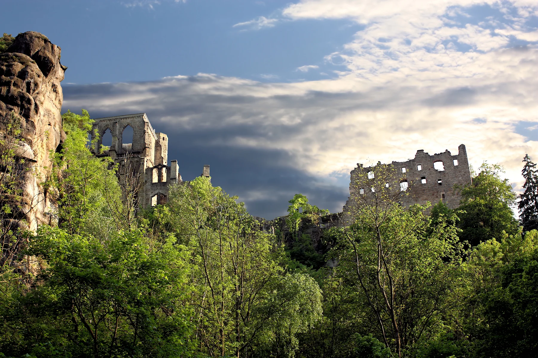
The stop matters because it prevents the route from mistaking bleakness for depth.
There is nothing intellectually weak about enjoying a beautiful place.
The mistake would be claiming that beauty explains the region.
After Oybin, drive to Zittau and stay there.
Zittau looks finished in the centre and unresolved around the edges
Zittau’s historical centre is attractive enough to support an easy evening.
That is useful after Ještěd and Oybin.
Walk the market square, eat somewhere central and let the first day remain relatively comfortable.
Then look beyond the restored façades.
One of the most visible reminders of the city’s unfinished transition is the enormous Mandaukaserne, a former military barracks whose future has been debated for years.
The building has undergone emergency stabilisation, but no simple redevelopment story has followed. Local reporting continues to treat it as one of Zittau’s most difficult monumental properties.
It is visible from public space.
That is where you should remain.
The current local reporting on the Mandaukaserne provides more useful context than entering a dangerous building to photograph the same broken corridor everybody else photographed before the floor weakened further.
Zittau is not a ruined city.
That distinction matters.
It is a functioning small German city with restored streets, awkward properties, demographic pressure and immediate access to Czechia and Poland.
Stay in or near the centre.
Do not choose an isolated rural hotel merely because the room is €12 cheaper. The point of the overnight stop is being able to walk, eat and stop driving.
Day 1 in practice
A realistic schedule:
- 08:30 — leave Liberec;
- 09:00–11:00 — Ještěd;
- 11:00–12:00 — descend and continue towards Hrádek nad Nisou;
- 12:30–15:00 — Oybin, including lunch or a simple meal;
- 15:30–16:00 — reach Zittau;
- late afternoon and evening — Zittau centre and the public exterior around the Mandaukaserne.
This is not a rigid itinerary.
It is protection against spending four hours at Ještěd and arriving in Oybin when the gate is closing.
Day 2 — Zittau to Görlitz through the active hole in the map
Day 2 is the core of the route.
It is also the least conventionally attractive.
Leave Zittau and cross into Poland towards Bogatynia.
The drive is short. The change is not.
Bogatynia is shaped by the Turów mining and power complex nearby. It is a functioning town whose economic logic is unusually visible from the road.
Do not arrive expecting a ruined industrial settlement.
Supermarkets operate. People go to work. Streets have been renovated unevenly. Ordinary life continues beside infrastructure large enough to dominate the entire region.
That is more interesting than a ghost town.
Ghost towns are easy.
Living beside an expanding open pit is not.
Opolno-Zdrój is not abandoned
Continue towards Opolno-Zdrój.
The name still carries the memory of a health resort. The current village sits directly beside the mining landscape and has repeatedly faced uncertainty connected to the future of Turów.
It is frequently described online as abandoned or disappearing.
That is inaccurate.
People still live there. It remains an officially recognised village within the Bogatynia municipality. In 2026, the municipality was still commissioning work connected to the revitalisation of its park space.
This does not mean the village is thriving.
It means it is inhabited.
Treat it accordingly.
Drive slowly. Park where parking is legitimate. Do not photograph residents through windows or treat every neglected building as evidence collected for an expedition report.
The strongest thing about Opolno-Zdrój is not that it resembles a ghost town.
It is that it has not become one, despite living beside a landscape that keeps placing its future in doubt.
Turów is more disturbing because it is still working
The Turów lignite mine is an active open-pit mine.
It supplies lignite to the adjacent power station. Mining activity here predates the current Polish operation and forms part of a much longer industrial history in the three-border region.
This is not industrial heritage.
It is industry.
That changes how the stop must be approached.
There is no officially promoted visitor platform that guarantees a perfect panoramic view of the mine. Public access around the perimeter can change with works, security and road arrangements.
Do not follow an old viewpoint pin blindly.
Do not drive through a barrier because a satellite image suggests the road continues.
Do not launch a drone over active industrial infrastructure.
Use public roads and legal stopping places. Accept that the most dramatic machinery may remain distant or partly hidden.
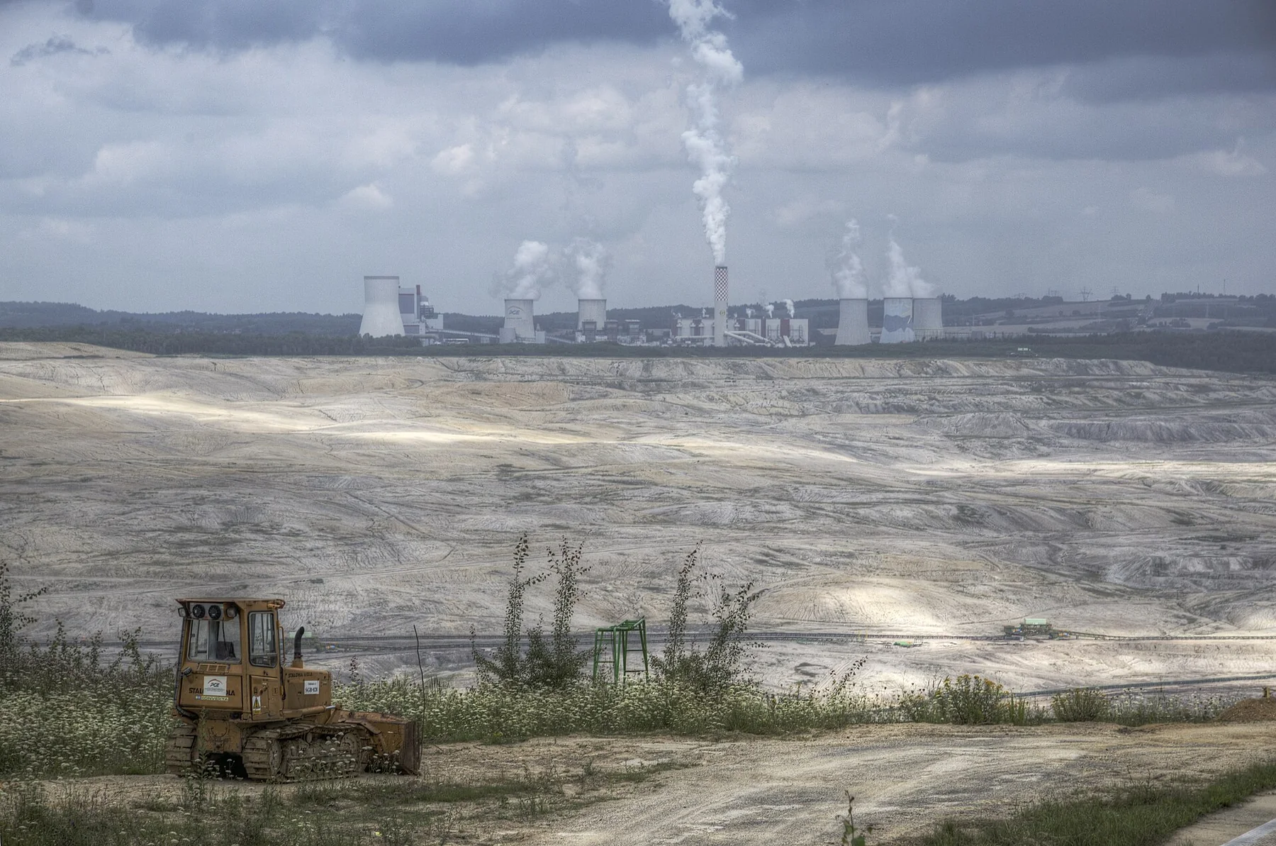
Turów works as a route phase rather than one precise viewpoint.
Notice:
- the scale of the excavated landscape;
- conveyor infrastructure;
- the power station;
- altered horizons;
- roads and settlements forced to organise themselves around the mine;
- the uncomfortable fact that the site is simultaneously an employer, energy asset, environmental dispute and physical hole in the ground.
The route should not tell you what political conclusion to reach.
It should make the size of the argument visible.
Do not turn the mine into a spectacle and the town into scenery
The temptation around Turów is to frame everything through extraction.
Bogatynia becomes “the mining town”.
Opolno-Zdrój becomes “the dying village”.
Every resident becomes a supporting figure in somebody else’s industrial road story.
Resist that.
The mine dominates the regional economy and landscape.
It does not explain every person living beside it.
Stop for lunch in Bogatynia or another functioning town rather than treating the area exclusively as visual material. Use local businesses. Behave normally.
You are visiting somewhere people live, not inspecting a failed simulation.
Görlitz is the contrast the route needs
After Turów, continue towards Görlitz and Zgorzelec.
The arrival is almost suspicious.
Görlitz has one of Germany’s most intact historical centres, with streets and buildings representing several architectural periods without the heavy reconstruction effect common in more damaged cities.
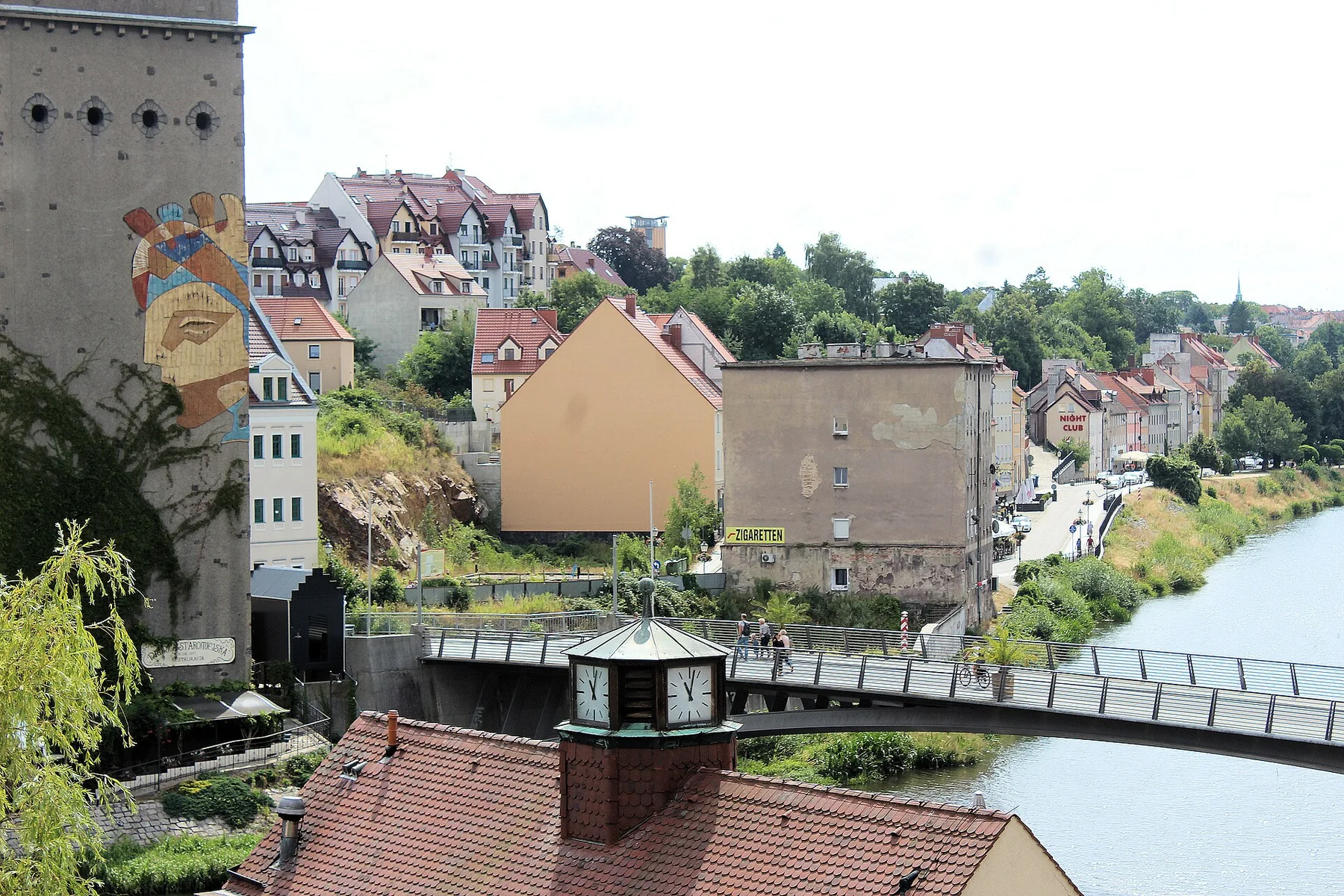
Across the Neisse, Zgorzelec continues the urban area inside Poland.
Walk across the Old Town Bridge rather than treating the border as a photograph taken from one bank.
The two sides are not mirror images.
That is what makes the crossing useful.
Görlitz provides the more complete historical stage set. Zgorzelec feels more ordinary and contemporary. The shared riverfront and bridge turn them into one practical evening without pretending national differences have dissolved.
Stay in either city.
Görlitz offers the more atmospheric old-town accommodation.
Zgorzelec can offer better value and easier access to Polish restaurants and shops. Compare the actual hotel and parking conditions rather than choosing a country as though one side is automatically cheaper.
The Görlitz Lost Places Tour is the legal urbex option
Görlitz also provides the route’s most credible answer to the urban-exploration impulse.
The official Görlitz Lost Places Tour enters former industrial premises, commercial buildings, courtyards and DDR-era relics that are normally inaccessible.
The walking tour:
- lasts around four hours;
- costs €25 for adults;
- operates only on selected dates;
- requires advance booking through the organiser.
This is not a casual evening activity.
When the schedule fits, it can become the central activity in Görlitz and may require rebalancing Day 2 or Day 3.
When it does not fit, leave it.
Do not replace an unavailable legal tour with your own route through boarded buildings.
The fact that a structure appears abandoned does not make access ambiguous.
It usually makes access closed.
Day 2 in practice
A realistic schedule:
- 08:30 — leave Zittau;
- 09:00–10:00 — Bogatynia;
- 10:15–11:15 — Opolno-Zdrój and surrounding public roads;
- late morning to early afternoon — Turów-area driving and observation;
- lunch in Bogatynia or on the route towards Görlitz;
- 15:00–16:00 — arrive in Görlitz or Zgorzelec;
- late afternoon and evening — old town, river and cross-border walk.
The day contains relatively little driving.
It can still feel heavy.
Do not add three abandoned buildings because the distances look short.
Day 3 — Glass, coal and landscape repair
Leave Görlitz and drive north towards Weißwasser.
The journey takes roughly an hour.
Weißwasser was shaped by glass production and lignite mining. During its industrial peak, it became one of Europe’s major centres of glass manufacturing.
The city later faced factory closures, population loss and the broader restructuring affecting eastern German industrial towns.
Do not expect a spectacular urbex destination.
Weißwasser is more interesting as a city attempting to build something from its industrial remains.
The Gelsdorfhütte is becoming a landmark, not remaining a ruin
The former Gelsdorfhütte glassworks site is central to Weißwasser’s industrial history.
The surviving protected structures are currently being stabilised and incorporated into a larger redevelopment project. The city plans to make the retained industrial landmark publicly accessible as part of a new quarter, with work expected to continue into 2027.
The official Weißwasser project page explains the current status.
That means two things.
First, the site belongs in this route.
Second, it should not be described as an untouched abandoned factory waiting for explorers.
Construction, contamination work and redevelopment make access a changing technical issue.
View what is legally visible.
Then continue.
The route is not weakened because one industrial ruin is being reused.
That is part of the story.
Babina is where the damage stops looking industrial
From Weißwasser, continue towards Łęknica and the Muskauer Faltenbogen / Łuk Mużakowa UNESCO Global Geopark.
The geopark crosses the German–Polish border and combines glacial geology with a landscape heavily altered by lignite and clay extraction.
Its strongest roadtrip stop is the Polish Dawna Kopalnia Babina geotourist trail.
The complete route is approximately ten kilometres.
Three forest parking areas provide access from:
- Łęknica;
- Nowe Czaple;
- the regional road near Przewoźniki.
The full trail can take three to four hours depending on pace, stops and conditions.
Shorter sections are possible, but the site is not improved by seeing one lake and returning immediately to the car.
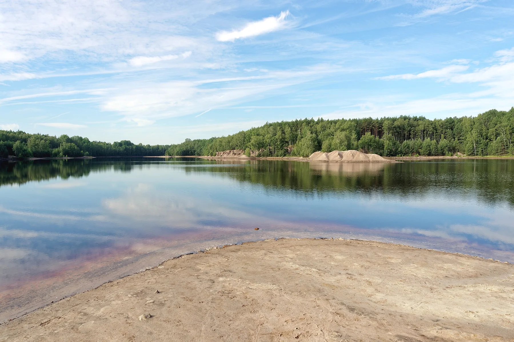
Former mining pits have filled with water. Iron compounds and other minerals influence the colours. Forest has grown around spoil heaps, cuts and old industrial routes.
The result is visually attractive.
It is not untouched nature.
That distinction is precisely why it belongs at the end of this route.
The landscape has recovered enough to become recreational without losing the physical evidence of what created it.
Walk it.
Do not merely photograph it.
Finish in Łęknica or Bad Muskau
After Babina, continue into Łęknica or cross into Germany to finish at Muskauer Park in Bad Muskau.
Muskauer Park occupies both sides of the Neisse and is recognised as a transnational UNESCO World Heritage Site.
It is formal, composed and carefully maintained.
That makes it an almost absurd ending after Turów, Opolno-Zdrój and Weißwasser.
Use the contrast.
Do not force another museum or tower into the schedule merely because Bad Muskau contains them.
The park and river are enough.
You have spent three days looking at landscapes and towns shaped by systems larger than themselves.
Finish somewhere that demonstrates landscape can also be shaped deliberately without being mined.
What the route costs
The route itself does not require expensive attractions.
The main fixed visitor costs are modest:
- Ještědka parking: 200 CZK (€8.28);
- Výpřež parking: 100 CZK (€4.14);
- Oybin Castle and Monastery: €9 from April to October or €6 from November to March;
- Görlitz Lost Places Tour, when available: €25.
Fuel and accommodation will form most of the budget.
Use current hotel prices rather than assuming Poland is always cheapest and Germany always most expensive. Görlitz can become costly on busy dates. Zgorzelec can offer better value, but not every Polish hotel includes convenient parking or a useful central location.
For rough currency conversion at the time of writing:
- €1 ≈ 24.16 CZK;
- €1 ≈ 4.32 PLN.
Card payment is widespread.
Keep some cash for small parking machines and minor purchases, especially when the published instructions explicitly require it.
The best season
Late spring to early autumn is the easiest period.
April to June
Good walking temperatures and longer daylight.
Mountain weather around Ještěd can still change quickly. Forest paths around Babina may remain wet after prolonged rain.
July and August
The longest daylight and easiest overall access.
Oybin and the better-known stops can be busier. Görlitz accommodation may rise around events. Hot weather makes the exposed sections of the Babina walk less pleasant.
September and October
Probably the strongest balance.
Forests change colour, walking temperatures improve and the industrial landscapes can look suitably severe without winter reducing daylight.
Do not romanticise autumn fog when you still need to drive through it.
Winter
Possible, but it becomes a different route.
Ještěd may require winter tyres and chains. The days are short. Oybin operates reduced winter hours. Babina paths may be muddy, icy or snow-covered.
Winter strengthens the atmosphere and weakens the practical margin.
Who this route is for
Drive it when you enjoy:
- border regions more than major capitals;
- architecture that reveals the political system that built it;
- industrial landscapes without requiring them to be abandoned;
- towns that need context before they become interesting;
- walking as part of a road trip;
- places that remain unresolved.
It works particularly well for travellers interested in:
- post-socialist Central Europe;
- lignite mining and regional transition;
- twentieth-century architecture;
- legal industrial exploration;
- altered landscapes;
- the difference between decline and disappearance.
Who should choose another road
Skip it when you need:
- spectacular driving roads;
- a famous attraction every two hours;
- luxury hotels and carefully staged lunch stops;
- guaranteed access to abandoned buildings;
- constant beauty;
- a route that explains itself immediately.
This is also the wrong trip for somebody who wants to collect grim photographs while treating residents as part of the scenery.
Bald curiosity can be useful.
Performative misery is not.
What will probably disappoint you
Turów may be difficult to see properly.
That is possible.
Opolno-Zdrój may look more ordinary than expected.
That is likely.
Weißwasser may not provide one unforgettable industrial monument.
That is not its role.
The route depends on accumulation.
A strange tower.
A border road.
A former spa village beside an active mine.
A perfectly restored German street.
A protected factory ruin becoming a development project.
A forest growing through former extraction pits.
No single stop carries the entire trip.
Together, they form the argument.
What makes the route worth three days
Ještěd shows what modernity was supposed to look like.
Oybin proves the region never belonged only to industry.
Zittau shows the uneven work of preserving and reusing a smaller city.
Bogatynia and Opolno-Zdrój show what happens when a mine becomes larger than the surrounding future.
Turów refuses to become nostalgic because it is still operating.
Görlitz restores beauty at exactly the moment the route needs it.
Weißwasser shows that industrial remains can become part of planning rather than only decay.
Babina shows that damaged ground continues changing after the machinery leaves.
That is why the road trip works.
Not because it discovers a hidden corner of Europe.
The region is not hidden.
It is simply difficult to market without simplifying it.
Drive it without demanding one clear emotion.
The route becomes much better once ugly, impressive, ordinary, alive and abandoned are allowed to occupy the same day.
Want the route file, not only the article?
This article deliberately shows the structure of the trip rather than every parking area, access road and optional detour.
Need a more detailed version?
[Email InstantTraveling](mailto:info@instanttraveling.com?subject=Black%20Triangle%20route) with Black Triangle route in the subject line.
Depending on what you need, we can prepare a more detailed stop list, a custom static map or a GPX-ready version of the route.
Image credits
Route photographs: Oybin monastery ruins by Dako99, CC BY-SA 3.0; Turów coal mine and power station by Petr Vodička, CC BY-SA 4.0; Altstadtbrücke between Görlitz and Zgorzelec by Dguendel, CC BY 3.0; Africa Lake at the former Babina mine by Jakub Hałun, CC BY-SA 4.0. Images were resized and converted to WebP for this page.


